Salt Road from Bad Sülze-Dändorf-Wismar, 1243–1907

erstellt von Photographer: Michael Gäbler last modified 2024-11-15T18:20:42+01:00
Wikimedia Commons, CC BY-SA 3.0
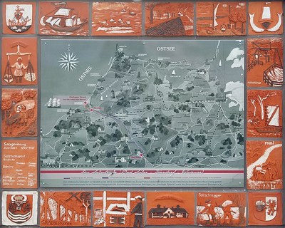
Die Salzstraße 1243–1907 Bad Sülze-Dändorf-Wismar, map, color photograph, 2013, photographer: Michael Gäbler; source: Wikimedia Commons, https://commons.wikimedia.org/wiki/File:Die_Salzstra%C3%9Fe_1243-1907_Bad_S%C3%BClze-D%C3%A4ndorf-Wismar.jpg?uselang=de, Creative Commons Attribution-ShareAlike 3.0 Unported, https://creativecommons.org/licenses/by-sa/3.0/deed.de.

Salzstraße Bad Sülze-Dändorf-Wismar 1243–1907 IMG

For a long time, salt was one of the few goods for which long, often arduous transportation routes were worthwhile. So-called salt roads were primarily constructed between salt works or mines and salt-poor regions. The color photograph shows an information board depicting the salt road between Bad Sülze via Dändorf to Dierhagen (and from there to Wismar) in Mecklenburg-Vorpommern in north-eastern Germany.


Die Salzstraße 1243–1907 Bad Sülze-Dändorf-Wismar, map, color photograph, 2013, photographer: Michael Gäbler; source: Wikimedia Commons, https://commons.wikimedia.org/wiki/File:Die_Salzstra%C3%9Fe_1243-1907_Bad_S%C3%BClze-D%C3%A4ndorf-Wismar.jpg?uselang=de, Creative Commons Attribution-ShareAlike 3.0 Unported, https://creativecommons.org/licenses/by-sa/3.0/deed.de.


Mitteleuropa
Migration, Reise, Wirtschaft, Technologie
IEG(http://www.ieg-mainz.de)
yes
Medienbeschreibung
HTML
EGO(http://www.ieg-ego.eu)
Englisch
2013
2013
2010 - 2019

Salzstraße Bad Sülze-Dändorf-Wismar 1243–1907
Salt Road Bad Sülze-Dändorf-Wismar
Bild
No image
Deutsch
Deutsch, Englisch
No file
No file